Geostatistics in application
In 30 years, the company Geovariances imposed itself as a lead actor in geostatistics, a scientific field that enables the estimation of a “reality” using data from various origins and in limited quantity, while quantifying the uncertainties attached to the estimation.
Quickly understanding the potential of a mine site from some borehole data coupled with other geophysical or geological data is strategic with regards to industrial efficiency and productivity. This is where geostatistics prevails, all the more so since mineral resources are more and more difficult to target because they are getting scarcer and even more scattered and deeper.
Leader in geostatistics software solutions, Geovariances guarantees its clients the reliability and scientific rigor of its products thanks to an exclusive 30-year partnership with the Center for Geosciences of the French school Mines ParisTech as well as tested and proven algorithms.
Since 1993, Geovariances develops and sells Isatis, a general purpose and comprehensive software solution in geostatistics, widely recognized as the reference geostatistical toolbox for thorough data analysis and visualization, quality mapping, accurate resource estimation and risk analysis.
To extend the use of geostatistics to a wider public that needs to produce trusted resources and quickly update models, Geovariances released Minestis last year, a geostatistics-based workflow dedicated to mineral resource estimation.
The continuous development of Isatis and Minestis software packages is based upon significant technical advances Geovariances has been responsible for over the years, some of which involve multivariate geostatistics. This latest can help mineral processing decision in several ways. Let’s see how.
Multivariate domain modeling helps better anticipate mineral processing adjustment needs
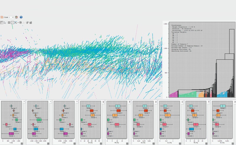
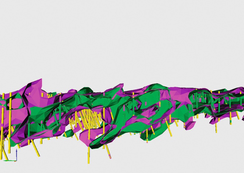
Minestis offers original techniques for domaining and domain modeling which complement traditional construction of geological domains. These techniques aim at capturing the behavior of variables controlling the mineralization process and defining spatial envelopes which help in grade estimation by identifying zones with homogeneous grade profiles.
Domaining in Minestis is based on a clustering algorithm (GHC - Geostatistical Hierarchical Clustering) allowing grouping samples into subsets (clusters) according to their degree of similarity in the cluster and their spatial dependency. GHC ensures reproducibility, auxiliary variables integration, conversion of subjective parameters into objective ones and easy updating. Domain modeling is based on the Potential Field method which uses geological, mining and production information for modeling geological boundaries and offers the key advantage of allowing the assessment of the uncertainties attached to them.
Production information (e.g. collected samples from sensors or geometallurgical data) is used to define the feed quality constraints and production limitations for mineral processing. Taking them into account for domain modeling can provide an effective solution consistent with flowsheet supply requirements in mineral processing plants. This could also help in better plan mineral processing adjustments due to possible variations in the feed.
Multivariate conditional simulations help optimize process control parameters of mineral processing
Good estimation has the goal of providing the “best” estimate for a block. This is achieved in kriging by tailoring the linear interpolation scheme to the level of variability observed on the data. However if we wish to deal with issues of variability, kriging has a downside. The means of achieving optimal estimation in kriging is to smooth the values to the detriment of reproducing the input variability. The appropriate geostatistical framework to provide a technically suitable answer to problems dealing with variability is that of conditional simulation.
A key property of conditional simulation models (as opposed to kriging models) is that a family or system of model realizations is generated, i.e. not just one “best estimate”. A series of images, or “realizations”, that presents a range of plausible possibilities is obtained, each reproducing the histogram and variogram of the input data, as well as honoring the known data points (hence “conditional”).
Conditional Simulations, and particularly multivariate simulations, thus provide an appropriate platform to study any problem relating to variability, for example stockpiling, stacking, reclaiming and blending different material types, in a way that estimates cannot.
Mutltivariate simulations (e.g. of gold and copper in a porphyry, grade and contaminants in an iron orebody; multivariate trace or deleterious elements for a coal product destined to metallurgical use, etc.), by reproducing the correlation between input variables, are the perfect conduit to optimizing the process control parameters of mineral processing.
Multivariate Uniform Conditioning helps quantify recoverable secondary elements, deleterious or precious
Univariate geostatistics is often not sufficient for estimating in a reliable way the recoverable resources in the main economic mineral of an orebody when secondary minerals are a constraint at the extraction or processing stages but ignored in the estimation.
The Localized Multivariate Uniform Conditioning method (LMUC) answers the issue by predicting the recovery functions on the secondary elements when selection is made on a primary element. A good example lies in gold exploitation. As sulfurs penalize the gold ore processing, estimating the recoverable grades of these sulfurs according to a given cut-off applied to gold is of crucial importance. Conversely, the presence of silver being often associated with the presence of gold, assessing the recoverable resource of silver according to a given cut-off on gold presents a definite economic interest. The technique helps improving the validity and thus viability of the project evaluation by integrating and respecting the links between the variables that impact on the project economics.
One good example is Newcrest, PNG which applied LMUC for its Lihir Gold Mine. Most of the ore at Lihir is refractory and is treated using pressure oxidation before the gold is recovered by a conventional leach process. Newcrest has completed a major expansion of the Lihir process plant which included the installation of a new crushing facility and upgrades to the ore processing plant in 2014. The plant expansion has increased the flexibility of the operation, improved the reliability of single pieces of equipment and lower fixed costs per tonne. The role of multivariate recoverable estimation in that regard is paramount as it allows optimization of the processing route for the ore according to its bivariate (Au, S) signature and paves the way for
● maximising direct feed ore to the autoclaves, thus reducing the proportion of ore fed through the flotation circuit, thereby reducing costs andincreasing gold recoveries and consequently total gold production;
● accelerating processing rates, bringing forward production and maximising value.
//www.geovariances.com" target="_blank" >www.geovariances.com:www.geovariances.com