Basis of utilization and development of technologies and
machinery (Part 2.1)
 Quelle/Source: Prof. Dr. Georg Unland, 2016
![1 Verbreitung des Oberkarbons und Lage der Steinkohlenreviere [29, S. 122] # The extent of the Upper Carboniferous and location of hard-coal fields [29, p. 122]](https://www.at-minerals.com/imgs/1/3/7/8/2/3/8/Bild_1-4a764ef81d338a94.jpeg)
![2 Ruhrkohlenbecken [37, S. 3] # The Ruhr Coal Basin [37, p. 3]](https://www.at-minerals.com/imgs/1/3/7/8/2/3/8/Bild_2-26cbf9c410c9dd2d.jpeg)
![3 Plattenbewegungen und -bildungen im Paläozoikum, [33, S. 142, 143] # Plate movements and formations during the Palaeozoic [33, p. 142, 143]](https://www.at-minerals.com/imgs/1/3/7/8/2/3/8/Bild_3-175b85d13e0be8fa.jpeg) Source/Quelle:Haupt Verlag AG
Source/Quelle:Haupt Verlag AG
![4 Nordwest- und Mitteleuropa im Oberkarbon [50, S. 176] # North-west and Central Europe during the Upper Carboniferous [50, p. 176]](https://www.at-minerals.com/imgs/1/3/7/8/2/3/8/Bild_4-06c9b62cc84baca9.jpeg) Source/Quelle: Haupt Verlag AG
Source/Quelle: Haupt Verlag AG
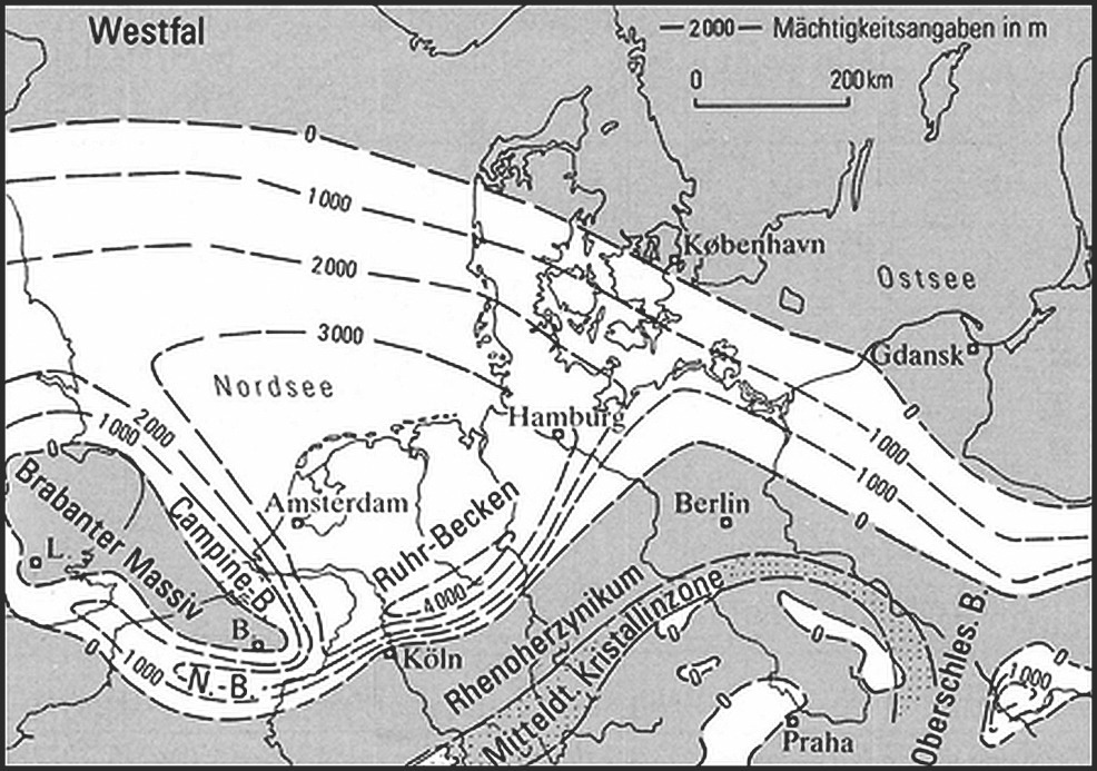
![5 Schichtmächtigkeiten im Namur und Westfal [9, S. 27] # Stratum thicknesses in the Namurian and Westphalian [9, p. 27]](https://www.at-minerals.com/imgs/1/3/7/8/2/3/8/Bild_5_links-f3bcbd4692c4518b.jpeg)
![6 Konzentration von Sauerstoff (O2) und Kohlendioxid (CO2) in der Atmosphäre (in Anlehnung an [31, S. 108]) # Concentration of oxygen (O2) and carbon dioxide (CO2) in the atmosphere (with reference to [31, p. 108])](https://www.at-minerals.com/imgs/1/3/7/8/2/3/8/Bild_6-aa069814579950ca.jpeg)
![7 Absenkungsraten im südöstlichen und nordwestlichen Teil des Ruhrgebietes (kompaktiert) [9, S. 28] # Subsidence rates in the south-east and north-west part of the Ruhr (compacted) [9, p. 28]](https://www.at-minerals.com/imgs/1/3/7/8/2/3/8/Bild_7-3d709bc3642c0e1b.jpeg)
![8 Meeresspiegelschwankungen im Karbon [33, S. 168] # Fluctuations in sea level during the Carboniferous [33, p. 168]](https://www.at-minerals.com/imgs/1/3/7/8/2/3/8/Bild_8_10-01-Karbon-Schema-9f65e00ade7594d6.jpeg) Source/Quelle: Haupt Verlag AG
Source/Quelle: Haupt Verlag AG
![9 Zyklische Sedimentation in subvariszischer Saumsenke [33, S. 174] # Cyclical sedimentation in subvariscan foredeep [33, p. 174]](https://www.at-minerals.com/imgs/1/3/7/8/2/3/8/Bild_9_FINAL-601c1586b2dc910f.jpeg) Source/Quelle: Haupt Verlag AG
Source/Quelle: Haupt Verlag AG
![10 Stratigraphie (Karbon, Ruhrbecken) [9, S. 31] # Stratigraphy (Carboniferous, Ruhr Basin) [9, p. 31]](https://www.at-minerals.com/imgs/1/3/7/8/2/3/8/Bild_10-da08df28e3b8ace9.jpeg)
![11 Petrographische Zusammensetzung des Ruhrkarbons [8, S. 39]](https://www.at-minerals.com/imgs/1/3/7/8/2/3/8/Bild_11-07f2bef306717a7c.jpeg)
![12a Stratigraphie und Flöze [16, S. 120] # Stratigraphy and seams [16, p. 120]](https://www.at-minerals.com/imgs/1/3/7/8/2/3/8/Bild_12a-13a88f22bfbd5387.jpeg)
![12b Stratigraphie und Flöze [16, S. 120] # Stratigraphy and seams [16, p. 120]](https://www.at-minerals.com/imgs/1/3/7/8/2/3/8/Bild_12b-14590d263dc1d473.jpeg)
![12c Stratigraphie und Flöze [16, S. 120] # Stratigraphy and seams [16, p. 120]](https://www.at-minerals.com/imgs/1/3/7/8/2/3/8/Bild_12c-7fcbcbf106911996.jpeg)
![12d Stratigraphie und Flöze [16, S. 121] # Stratigraphy and seams [16, p. 121]](https://www.at-minerals.com/imgs/1/3/7/8/2/3/8/Bild_12d-a5e73bf4a8e7fc8d.jpeg)
![12e Stratigraphie und Flöze [16, S. 122] # Stratigraphy and seams [16, p. 122]](https://www.at-minerals.com/imgs/1/3/7/8/2/3/8/Bild_12e-f8fe5c18e5a4ba30.jpeg)
![12f Stratigraphie und Flöze [16, S. 124] # Stratigraphy and seams [16, p. 124]](https://www.at-minerals.com/imgs/1/3/7/8/2/3/8/Bild_12f-819b9e071d2da1c8.jpeg)
![13 Tektonische Phasen [9, S. 155] # Tectonic phases [9, p. 155]](https://www.at-minerals.com/imgs/1/3/7/8/2/3/8/Bild_13-b92de226138bd0ef.jpeg)
![14 Faltungs- und Überschiebungstektonik [9, S. 44] # Folding and overthrust tectonics [9, p. 44]](https://www.at-minerals.com/imgs/1/3/7/8/2/3/8/Bild_14-85448b57cfe2ec17.jpeg)
![15 Axialstrukturen [9, S. 81] # Axial structures [9, p. 81]](https://www.at-minerals.com/imgs/1/3/7/8/2/3/8/Bild_15-89155221a3adc681.jpeg)
![16 Tektonik [9, S. 68] # Tectonics [9, p. 68]](https://www.at-minerals.com/imgs/1/3/7/8/2/3/8/Bild_16-25342ab0831a54c3.jpeg)
![17 Stockwerkbau (mittleres Ruhrgebiet) [9, S. 82] # Tectonic level system (central Ruhr) [9, p. 82]](https://www.at-minerals.com/imgs/1/3/7/8/2/3/8/Bild_17-ae83c4ec36fb4e4e.jpeg)
![18 Ausgestaltung der Bochumer Hauptmulde in der Hammer Achsensenke (a) und der Dortmunder Achsenaufwölbung (b) (Abstand der Schnitte 20 km) [9, S. 86] # Formation of the Bochum Main Syncline in the Hamm Axial Depression (a) and the Dortmund Axial Arch (b) (section spacing: 20 km) [9, p. 86]](https://www.at-minerals.com/imgs/1/3/7/8/2/3/8/Bild_18-e9ecdd0e66e934e6.jpeg)
 Source/Quelle:
SMF/momentphoto, Oliver Killig
Source/Quelle:
SMF/momentphoto, Oliver Killig
Summary: The geological properties of the bituminous coal deposit of the Ruhr area are presented as an example of the characterization of a complex structured deposit. The properties are determined by sedimentary bedded rocks and differently coalified coal seams as well as elements of the constricted tectonics (saddles, synclines, folds, overthrusts) and the extending fracture tectonics (grabens, horsts, faults). The coal seams with their different geometrical and material properties (depths, dimensions of sectional coal beds, dippings, lithotypes) required continuous development of mining technology and machinery in the past in order to justify coal mining supported by subsidies. There are still significant coal reserves left despite a 700 year mining history and a closing of all mines in October 2018. However, the reserves are marginal on a global level. These strategic reserves for Germany can only be economically used in the future if new technologies will be developed.
The succeeding part of the treatise discusses in terms of its characterization a complex deposit, namely the hard-coal deposit of the Ruhr area.
4 Hard coal deposits of the Ruhr region
From Ireland through to Russia, significant deposits of hard-coal were formed in Europe during the geological age of the Carboniferous (Fig. 1). In many countries, including Great Britain, France, Belgium and Germany, for example, these deposits formed the basis for industrial development and are even today the industrial backbone of many national economies, as is the case in Poland and in Ukraine.
The Ruhr‘s hard-coal deposits are Germany‘s most important reserves, since they supplied, thanks to their magnitude and their diversity of coal ranks, numerous feed materials for the chemical, metallurgical and energy industry. Their complicated geological structure presents special challenges to the processes and machinery used, however, and have therefore in the past been the initiator of numerous technical developments.
The Ruhr region also features other deposits, with potassium and rock salt in its north-western sector and strontianite deposits at the north-eastern transition to the Münsterland region. These, and also the iron-ore deposits historically so important for the iron and steel industry, and the also still considerable reserves of lead and zinc, will not be examined within the scope of this treatise, however. Only the rock salt deposits are nowadays still mined. The Borth mine produces rock salt of the Werra Sequence from the Zechstein Formation.
Derivation of the geological features of the Ruhr Basin‘s hard-coal deposits is made possible by an understanding of their genesis. For this reason, the evolution of these deposits will here firstly precede their geological characterization by means of their features. The “Ruhr” (or “Ruhr industrial region”) in the narrower sense makes up only one sector of the Ruhr Basin.
4.1 The hard-coal deposits of the Ruhr Basin
Coal-bearing Carboniferous strata extend to the north of the Rhenish Massif under the North Sea. The coal seams outcrop at the boundary of this massif. To the north they dip below an ever thicker overburden.
Within this region, the Ruhr Coal Basin extends in the south from the northern boundary of the Rhenish Massif, where the seams frequently diverge toward the surface and outcrop at certain points in the valley of the Ruhr river, from which the region takes its name, up to an area to the north of the Lippe river, where these strata are found at depths of more than 1000 m. Two structures, the Lippstadt and the Krefeld highs, bound the Ruhr Coal Basin in the east-to-west direction (Fig. 2).
4.1.1 Genesis
Coal was formed in the Upper Carboniferous. Only the complex interaction of various processes and effects in the lithosphere, hydrosphere, atmosphere and biosphere prior to, during and after the geological period of the Upper Carboniferous permitted the formation, accumulation and preservation, in swamps, of large quantities of biomass consisting, in particular, of vegetable matter from which the hard-coals were ultimately formed as the result of geological, physical, chemical and biological processes [9, 10, 14, 16, 26, 31, 33, 37, 38, 50].
4.1.1.1 Pre- and syncarboniferous development in the lithosphere
The territory of the present-day Ruhr region was located during the Palaeozoic between the continents of Laurussia and Gondwana. During the Silurian period, the continents of Laurussia, in the north, and Gondwana, in the south, and also the microplates previously detached from Gondwana and located between these, the Armorica terrain complex and the Avalonia terrain, were separated by seas. During the Upper Silurian and Devonian, the intervening oceans were closed by the movement of the microplates and of Gondwana to the north. Avalonia firstly docked onto Laurussia at the end of the Silurian and ultimately onto Armorica and Gondwana during the Carboniferous (Fig. 3). Together with other continental plates, they formed, during the Carboniferous and the Permian, the supercontinent of Pangaea. Subduction, deformations, upthrusts and overthrusts of partial plates, and also the generation of faults and volcanism, occurred in the course of these plate movements.
The Variscan mountain range was formed from the convergent movement of Gondwana and Laurussia. The Variscan Orogeny encompassed in this context the region between the southern boundary of Laurussia and the northern boundary of Gondwana, including the intervening Avalonia and Armorica microplates. This orogeny ultimately resulted, during the Upper Carboniferous, in the formation of a high mountain range on the territory of the present-day Rhenish Massif (a part of the Rheno-Hercynian Zone) and of a subvariscan foredeep adjacent to the north, which was part of a larger basin structure extending up to the southern perimeter of present-day Scandinavia and Scotland. The Ruhr basin was a part of this foredeep. It was formed in the outlying coastal region of the northern boundary of the Variscan Orogeny (Fig. 4).
The erosion of the Variscan mountain range and the filling of the foredeep with clastic sediment resulted in the formation of a molasse basin of many thousand metres in thickness, the load exerted by which caused it to sink further (Fig. 5). Swamps, the biomass of which provided the matter from which coal was created, were able to form temporarily during the basin‘s descent. Subsequent covering by water and sediments prevented the degradation of the biomass and caused coalification as a result of rising pressures and temperatures during the further descent of the now filling trough.
4.1.1.2 Carboniferous development in the atmosphere and biosphere
Plants spread on the land area, and trees developed in the course of the Devonian. The territory of the present-day Ruhr region was located in the southern hemisphere and migrated further to the north, into the vicinity of the Equator, during the period of the Carboniferous. The climate became moist and hot, i.e. tropical. Enormous tropical forests, consisting primarily of plants of the fern family (lycopodiaceae, equiseta, ferns) were able to propagate in the coastal region, in particular [12, 33]. This process was accompanied by rapidly rising photosynthesis and silicate weathering, causing the CO2 content of the atmosphere to fall. Carbon dioxide, and thus also carbon, were fixed to a very large extent in the form of biomass and thus, ultimately, in the form of coal, and also chemically bonded in animal skeletons and shells, and therefore ultimately in the form of carbonate rocks. Climatic conditions during the Carboniferous were thus shaped not only by geographical location, but also by the steep increase of oxygen in the atmosphere, which rose to a historic peak of above 35 %, and by the virtually complete disappearance of carbon dioxide [31] (Fig. 6).
The reduction in the greenhouse effect caused by the climate-gas CO2 subsequently resulted in a reduction in temperatures on the Earth and in the ice formation on parts of Gondwana. Cooling down of the global climate and the reduced level of CO2 caused a reduction in the production of biomass and thus of oxygen in the atmosphere, not least as a consequence of the elevated solubility of this gas in water. Volcanism resulted temporarily in the emission of greenhouse gases such as carbon dioxide and methane into the atmosphere. These processes then caused renewed warming. The repeated shifts in the equilibrium between O2 and CO2 fixing and O2 and CO2 liberation into biomass, water and rocks thus initiated global climate changes and therefore fluctuations in ocean levels as a consequence of the differing aggregate states of water (liquid water and ice). The possibility that astronomic effects, such as fluctuating solar activities and changes in the Earth‘s orbit, may also have made their contribution to climatic changes can also not be excluded.
4.1.1.3 Carboniferous development in the hydrosphere and biosphere
Between the northern boundary of the Variscan mountain range and the southern boundary of Laurussia a basin (Fig. 4) was formed during the Upper Carboniferous which exchanged water with the Paleo-Tethys Ocean (Fig. 3). Rivers carried large quantities of weathering detritus from the adjacent mountains into the basin, and this accumulated in the form of clastic sediments. Fluvial landscapes with deltas of extensive area thus formed in the coastal region of the northern boundary of the Variscan mountain range. Lush tropical vegetation flourished in this region.
The dying plants resulted in the formation of humus and anaerobic sludge at corresponding groundwater and water levels, and thus of swamps. The sedimentation and formation of biomass were controlled, on the one hand, by the solid detritus of the rivers and the expansion of the swamps and, on the other hand, by the descent of the basin and fluctuations in sea level. The tectonic rate of descent of the basin, of an average of less the 1 mm per year [9] (Fig. 7), was significantly less than the fluctuations in sea level [17, 31, 33] (Fig. 8). The fluctuations in sea level in some cases reached height differences of well over 100 m during the Upper Carboniferous. River courses, and thus the formation of deltas, altered as a consequence. These constant displacements of the deltas for their part caused a change between land and sea and a change in the local groundwater table, a factor which was critical in the formation of the swamps. Large-scale swamps were formed in this way. Subsequent coverage of the swamps by water and/or sediments prevented the decomposition of the biomass and was a precondition for the formation of coal.
It is necessary to differentiate in principle between two different routes for the formation of swamps and thus of coal seams. Thanks to the fluctuation in sea level, the sea pushed the coastal swamps inland when rising (transgression), whereas the swamps followed the retreating sea when it fell (regression). Transgressive swamps, and later seams, are for this reason generally covered with fine-particled clayey sediments with inclusions of marine or brackish flora and fauna (Fig. 9), whereas regressive swamps/seams are frequently overburdened by sandy sediments. The series of strata between two seams is referred to as a “cyclothem” or a “sequence” [5, 10, 31, 33, 39, 42].
4.1.1.4 Syn- und post-Carboniferous development in the lithosphere
The continuous descent of the basin permitted adequate accumulation and adequate quantities of organic materials in the maritime littoral region, which then provided the basis for the formation of hard-coals (paralic deposit formation). Within a – in geological terms – relatively short period (Namurian, Westphalian) of not even nine million years, several thousand meters of sediments were deposited [1, 9] (Fig. 10). Diagenesis then ultimately resulted in the formation from this, at corresponding pressures and temperatures, of mudstones, siltstones and sandstones, and also coals (Fig. 11). A total of more than two hundred coal seams of various thicknesses (Fig. 12) can thus be differentiated and make up, taken together, around 2 to 3 % of the entire coal-bearing strata sequence of Namurian C and of Westphalian A to C [8, 9, 16]. With the beginning of Westphalian D, the 5 to 7 km thick basin filling has up to today then been exposed to mechanical and thermal loads.
The intensity and direction of these loads have had extremely differing courses, however. Phases exposed to virtually uniform and constant static loading alternated with phases with locally severe and differing stressing, which resulted in corresponding fractures and thrusts within the native rock (Fig. 13). Reversal of the direction of stressing even resulted in inverse thrusts. Plutons rose locally, as a result of magmatic events. For this reason, it is not possible even today to assign all geological processes precisely to the individual phases [9]. Despite these difficulties, the most important tectonic processes in derivation of geological features will be examined here.
During the late phase of the formation of the Variscan mountain range, the coal-bearing sediments of the Upper Carboniferous deposited in the subvariscan foredeep were exposed to stressing by pressure of a north-western orientation as a consequence of the continued movement of Gondwana towards Laurussia. The seams were shortened by up to 50 % in this process. The strata of the Ruhr Basin were thus deformed to folded and overthrust structures, the intensity of folding decreasing toward the north. Synclines and anticlines striking south-west to north-east were formed, as were overthrusts of great extent in some cases, such as the 80 km long Sutan Overthrust, which features overthrust magnitudes of up to 1.3 km. The deformation ultimately came to an end, and terminated at the deformation front.
The deposits are thus subdivided into four zones in the south-east to north-west direction. The southernmost zone, which extends from the no longer coal-bearing Remscheid Anticline up to the Stockum Main Anticline, consists predominantly of folded structures and less pronounced overthrusts. The Stockum Main Anticline up to the Vestisch Main Anticline adjacent to the north is characterized by pronounced main anticlines and main synclines with superimposed folding and by, in some case major, overthrusts. Shallow and wide synclines and narrow, folded anticlines, with no major overthrusts, dominate in the adjacent zone from the Vestisch Main Anticline to the outer boundary of the folded Variscan Orogeny, the Billerbeck Main Anticline. The fourth zone is located outside of the folded Variscan Orogeny, to the northwest of the deformation front, which strikes from Krefeld to Ibbenbüren [9, 38] (Fig. 14).
During the Variscan Orogeny, zones of axial corrugation running from south-east to north-west were also superimposed on the folds. The highs (axis culminations) of the Krefeld high in the west and of the Lippstadt high in the east bounded on the Ruhr Basin. The coal-bearing strata were elevated here, and subsequently eroded. An intruded pluton in the area of the Krefeld high caused the anthracitisation of the coal occurring there.
The Ruhr Basin, as a macrotectonic axis depression zone, was subdivided by a less severely elevated axis combination, the Dortmund Axial Upheaval. The low points of the axes, the Gelsenkirchen and Hamm axial depressions, are located between these culminations [9, 37] (Fig. 15).
Normal and lateral faults, their fault heights and spans of which in some cases reached several hundred metres, also evolved in several subvariscan and post-Variscan phases. The oldest movements can be ascertained during the Variscan Orogeny and then during the Rotliegend and in particular the Keuper geological periods. The Pangaea supercontinent fragmented during these periods and the North Atlantic opened. In this process, the strata of the Ruhr Basin were elongated by up to approx. 5 %, particularly in the east-to-west direction. In the context of the later Alpine Collision between the African and European plates during the Upper Cretaceous, the strata were again subjected primarily to compressive loading of a north-to-south orientation. Finally, reactivation of the fracture tectonics can be ascertained during the Tertiary period. [9] (Fig. 13).
The result was the occurrence of transverse faults perpendicular to diagonal to the strike of the fold axes, these transverse faults dividing the Ruhr Basis into horsts and grabens (Fig. 16). The direction of strike of the fractures is predominantly north-west to south-east with fault heights of up to above 1000 m (e.g. the “Sekundus-Sprung” in the vicinity of the Gelsenkirchen Main Anticline). Lateral faults also occur in the north-to-south direction, but these most frequently have an east-to-west orientation. The folded structures of more than 1000 m may be dextrally faulted as a consequence of this lateral fault (e.g. the “Wambeler Blatt” in the Witten Syncline).
The coal-bearing strata of the Ruhr Basin were thus shaped during and after the Variscan Orogeny by folded structures, axis corrugation and fractures. Tectonic stockworks formed in the vertical direction as a consequence. In general three tectonic levels can be differentiated with the same orogenic confinement [8, 9] (Fig. 17).
In the first, top, level there occur a few folds of great span and high amplitude, these forming wide trough synclines and high main anticlines with steep sides. Special folds and overthrusts can be found only in the main anticlines. The second, medial, level is characterized by folds of short to moderate spans and of low amplitude, and by special folds and frequent and pronounced overthrusts in the synclines. The third, bottom, level exhibits short-span special folds of low amplitude, with the result that it is not possible to differentiate main anticlines and main synclines in structural terms. Overthrusts are an only subordinate feature here.
The number of folds thus rises as depth increases, whereas their amplitudes and spans decrease. The overthrusts in the medial level served as compensation areas between the various modes of folding of the top and bottom stockworks. The levels in the Ruhr Basin are not a function of the age of the strata but, instead, stratigraphically identical strata may form part of different levels as a function of the corrugation of the fold axis, as is illustrated, for example, by the tectonic levels of the Bochum Main Syncline (Fig. 18).
The article will be continued in the next issue, AT 01-02/2019.